

This trail was a last-minute decision as Dan, Alissa (who decided to backpack again after our Rocky Mountain trip in 2021!), and I sat in a hotel bar in Portland contemplating the reasons why we shouldn’t do our original trail. It was July and snow was still a factor on Mt. Hood, so the Timberline Trail didn’t seem possible. Since we were in a central location to many great hikes, we could easily pick up another one. We wanted to make sure our trip had the right mileage to make our trek there worthwhile.
Each of us tagged a few replacement hikes on our AllTrails apps. This one was our top pick and with little information about the trail, we ventured on!
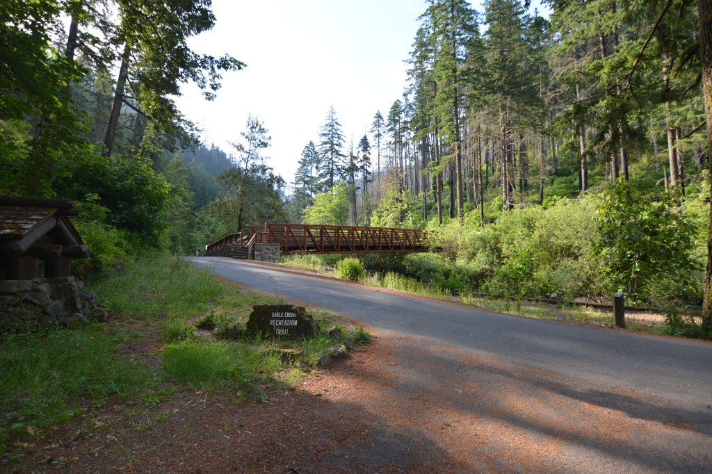
Trailhead: Eagle Creek Trailhead (#440)
Out & Back: Eagle Creek Trailhead & Trail (#440)
Distance: 25.8 Miles (1-2+ nights depending on your side trails and/or abilities)
Time of Year: Summer (4th of July weekend)
Traffic: Low on Friday, High on Saturday
Maps: AllTrails (Downloaded)
Trail Background
Eagle Creek: What’s it all about? Check out the Forest Service info here.
Highway 84 takes you along the Columbia River Gorge, a river canyon with dramatic scenery, cliffs, and a river as far as the eye can see. It flows from east to west into the Pacific and signifies the border between Oregon and Washington. In it lives the recreation area known for its waterfalls like the popular Multnomah Falls. Eagle Creek Trailhead is also in this stretch, only 45 minutes from downtown Portland, and 18 minutes from the falls, lending it to be a perfect place to explore what the Columbia River Gorge has to offer.
Having not read too much about the trail, we were surprised every step of the way on how beautiful this trail was.

The Trail
Start/End Point: Eagle Creek Trailhead
The trailhead had a relatively decent-sized parking lot next to a set of restrooms. We got there early enough to park with no problems (~8 AM) alongside only one or two other cars in the parking lot. On the information board was a digital pass for parking if you didn’t have an annual recreation pass. With full service, accessing the pass and paying for it was no problem.
We took the paved trail past the restrooms and joined up with the main road. There we saw our first glimpses of the trail- a painted rock with the trail name, a bridge, and the creek itself- under the blue light of the morning.
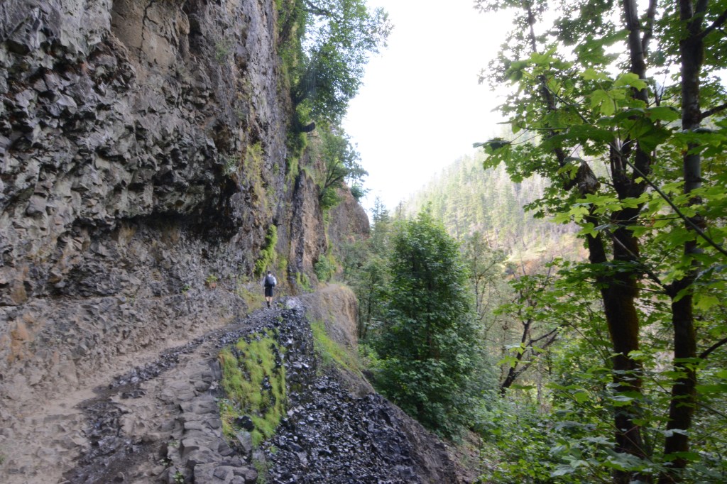
First ~1/2 Mile: Cable Trail
It only took the first half mile to discover what this trail was going to be like. Carved out of the rock wall was a narrow pathway leading upward, following the creek. In some places, the trail was eroded, there was water streaming off the slides from the snowmelt, sometimes in sprinkles, sometimes with more pressure. Hugging the wall seemed like a good option. There was a good portion of this section that even had a cable secured to the wall.
On the way up, we didn’t run into too many people, but on the way down, it was crowded and slow-moving. Many people were stopped trying to take selfies or moving slowly due to the drop off. Sometimes we safely went around people to keep pace.
Mile 1.6: Metlako Side Trail
You can follow Eagle Creek Trail to reach your destination, but there are a couple of side trails- some that look like other people created them. At this side trail, you are met with a large open space with options to go straight down this hill to reach Metlako Falls and Lower Punch Bowl Falls or turn left and continue along Eagle Creek. We skipped the side trail. Looking back, I wish we could have checked this out and put our feet in the water, especially after noticing how many people were traveling down there with towels on our way back.
Mile ~2: Punchbowl Falls
Even if you don’t take Metlako, you can still enjoy the falls from a lookout point! This waterfall is as beautiful as anything you would see in pictures, and it’s only two miles in!

Mile ~3.2: Loowit Falls
At many points along the trail, there are creeks and other forms of run off that create the water falls we saw, like Loowit Falls, or are just an obstacle for us to cross while we hike. This waterfall is ~60 feet.
Mile ~3.3: High Bridge
You can see this bridge up the canyon from Loowit, suspended 100 feet above Eagle Creek.
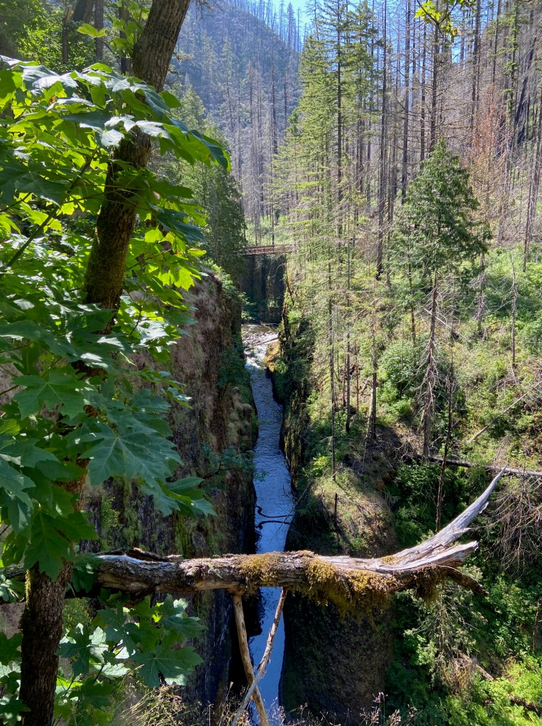
Mile ~4.5: 4 1/2 Mile Bridge
We crossed this bridge going toward the lake on Day 1 and didn’t take much notice of it. On the way back, there were people taking a break to picnic, so we did the same. It was a great spot to put your feet in the water and enjoy the sunshine!
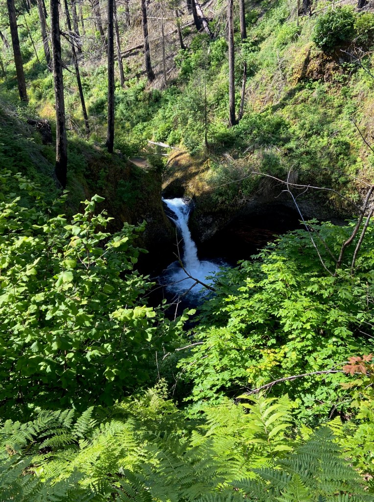
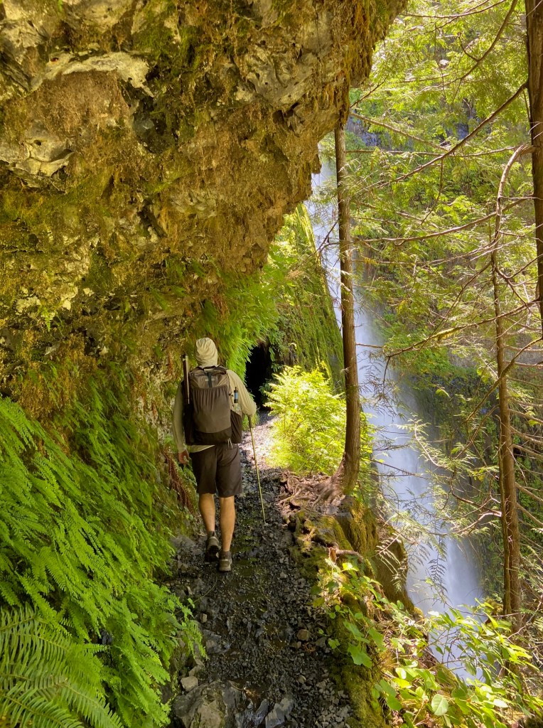
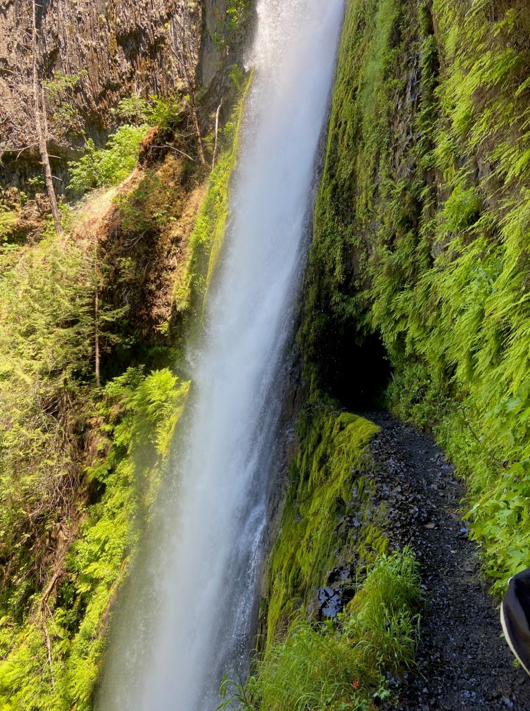
Mile ~5.8: Tunnel Falls
This waterfall came as a surprise to us- like I mentioned, we did minimal research before we jumped on this trail. When we turned our last bend, we stopped in amazement. In front of us was a waterfall cascading 175 feet into the creek. When we got even closer, we realized the trail was going behind the waterfall in a tunnel and the other side was wet and had another one of those cables to hold on to.
When we saw this on day 1, we had it to ourselves. On day 2, it was a Saturday around noon and overflowing with people waiting and taking selfies. We realized that this was a popular day hike, and that the waterfall was the turnaround point for most people.


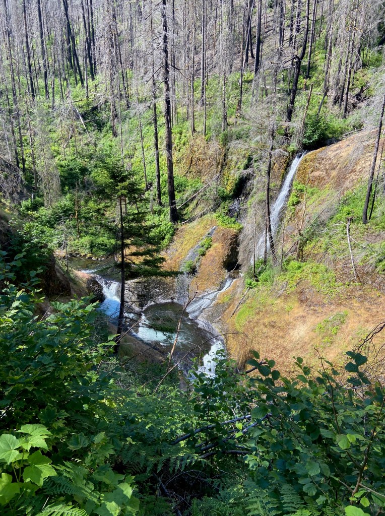
Mile ~6.1: Twister Falls
Tunnel Falls was not the only large waterfall, but it is the most prominent as far as pictures go with the way it is cut out of the mountain. Twister Falls also drops at similar feet in a different section. It looks like rushing water pushing itself together at an angle over the basalt rocks, which is where the twist comes from. We were level with the creek again, so the dramatic drop offs were at a minimal for the time being.

Mile ~7: 7 1/2 Mile Camp (not quite 7 and a half miles)
This is where we start hiking uphill, passing people who stopped to picnic, put their feet in the water, and even a person camping at 7 1/2 Mile Camp. We kept going instead of making it a two-night trip. This is the point of the trail where you are slowly moving up in elevation, it was more forested, and there were less people heading in the direction of the lake.


There are two side trails after this point to ignore-an Eagle Creek maintenance trail and the Indian Springs Trail #435 that links up to the Indian Springs Campground and the PCT.
Some parts of this trail are also rough due to snow melt and erosion on the trail. Some parts are thin and there are many places for tripping. We also encountered a few spots where you needed to hop over logs or go under them because they were obstructing the path.
Somewhere on this path between the two camps on the way back, our friend stepped down, landed in a hole, and sprained her ankle1. Since there was no other way down, she carried her weight on her trekking poles and limped painfully back to the car for over 10 miles.
Mile ~10.8: Upper Eagle Creek Camp
This was a beautiful camp next the creek. If you plan on camping at the lake and you are not hiking the PCT, this is a great secondary option. We ventured on our last (tried) two miles.
Mile ~12.9: Wahtum Lake
Eagle Creek and the PCT intersect at the lake. We turned right toward the Wahtum Lake Campground and found a spot by the river a few minutes later. The campground was further down and was more of a group camp, so we opted to stay in our smaller camp. Unfortunately, it was pretty bug invested! If you manage to make it around the lake, there are more spots with a view of the lake and many more voices on the opposite side.


While we were packing up the next day, I was surprised with how many people we saw- not just PCT hikers, but families with kids and dogs.
The Turnaround
The next day, we did everything in reverse. We usually only do out-and-backs for small day hikes, but it was nice on this trail to know what to expect on the way back. I was really happy that we had the first day to ourselves to enjoy each of the landmarks, so there was no need to take photos or stop on the way back. We pushed through, minus the sprained ankle and the amount of people on the trail.
Notes:
~all mileage is approximate.
~ 1I only mention this briefly, but it’s important to note that situations like this are sometimes unavoidable. My friend was walking on uneven terrain, the same terrain she walked on the day before, and unfortunately, she ended up getting hurt. Here are some items to bring in case of an emergency (even “small” ones): extra clothes and food, light gear, trekking poles, a full first aid kit, a GPS or satellite device like the Garmin inReach Mini, a lighter or matches, a fire starter, and a water filter.
Before & After
Non-trail notable places on our journey:
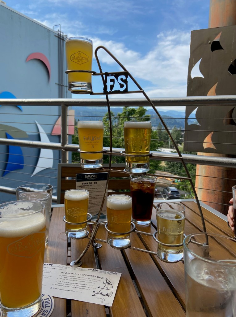
Brews: Full Sail Brewery in Hood River (~25 minutes East of Eagle Creek, ~1 hour from downtown Portland)
Coffee: Java Man Coffee in downtown Portland
Book store: Powell’s Books

Side trip: Multnomah Falls


Leave a comment